Objectives
There are two specific objectives of this study. One is to assess the regional diversity of Bangladesh through a multi-criteria spatial analysis combining socio-economic, structural, and ecological indicators. The other one is to identify which districts of Bangladesh are underdeveloped, which ones are developed and which ones are developing.
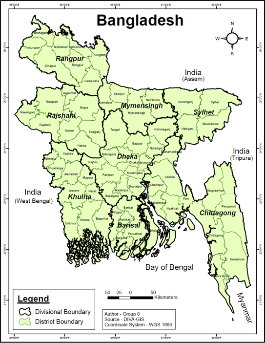
Study Area
Bangladesh, located in the Ganges–Brahmaputra delta, is a densely populated country with marked regional differences shaped by environmental, economic, and social conditions. While major cities like Dhaka have seen rapid growth with better infrastructure, services, and employment opportunities, many peripheral regions remain comparatively underdeveloped. This imbalance is influenced by uneven industrial concentration, limited access to healthcare and basic services, and varying ecological conditions such as flooding, salinity, drought, and extreme rainfall across different parts of the country.
These contrasts create a clear pattern of regional diversity, where some areas continue to lag behind despite overall national progress. Understanding these spatial differences is important to identify gaps in development and to support more balanced planning. This study focuses on examining such regional disparities across Bangladesh to highlight the underlying factors and guide more equitable distribution of resources and opportunities.
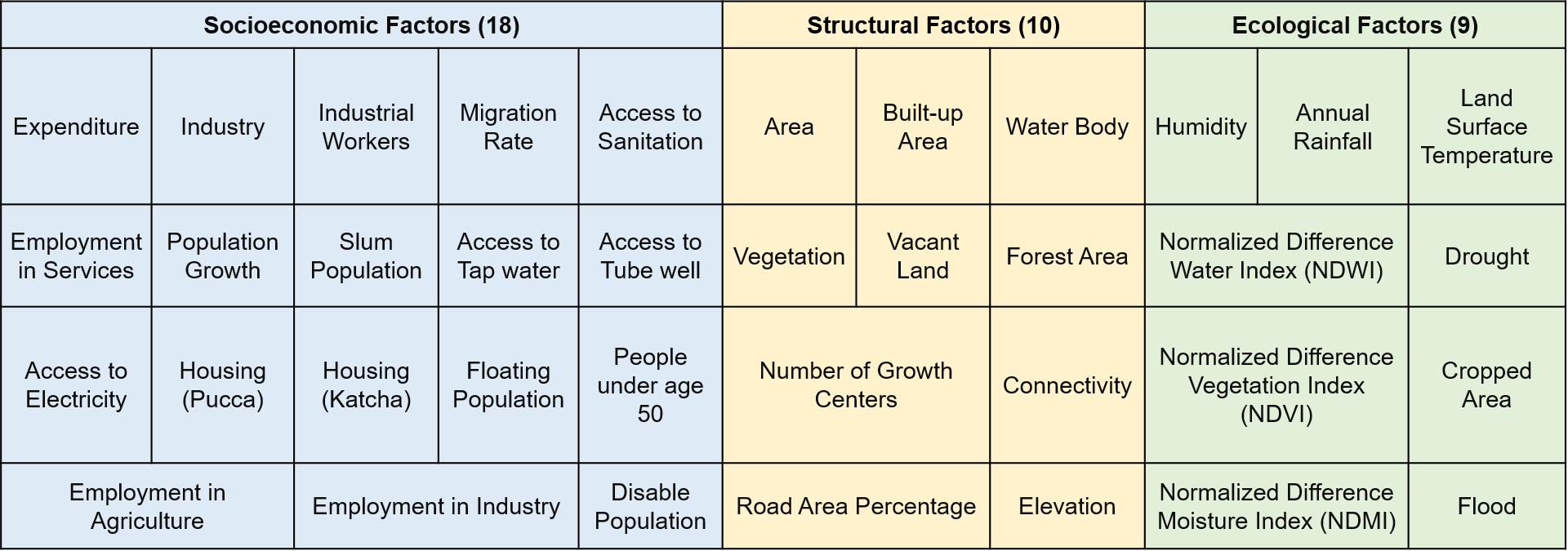
Factors
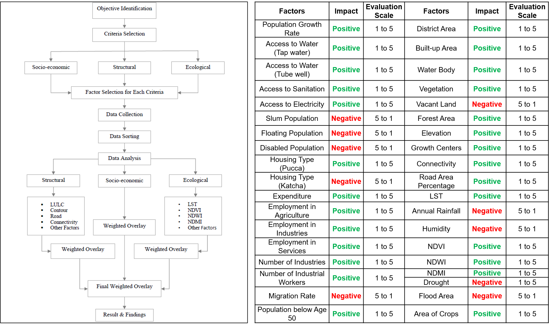
Methodology
- Data Collection: Satellite imagery (Sentinel-2, Landsat-8, DEM) and secondary data (Bangladesh Bureau of Statistics, World Bank).
- Pre-processing: Computed remote sensing indices such as LULC, LST using Google Earth Engine (GEE).
- Thematic Mapping: Generated district-wise maps for LULC, elevation, drought, and flood susceptibility.
- Categorical Weights: Socio-economic (45%), Structural (30%), Ecological (25%)
- Reclassification & Scoring: All factors were normalized to a 1 to 5 Likert scale (Jenks method). Positive and negative impacts were adjusted accordingly.
- Weighted Overlay: Combined all standardized layers to produce a composite Regional Diversity Map of Bangladesh.
Key Findings (LULC)
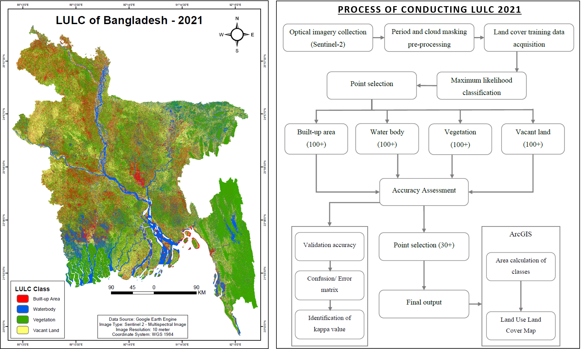
- The LULC 2021 map was developed using Sentinel-2 imagery and a supervised classification process (Maximum Likelihood Classification).
- Vegetation covered 47.26%, built-up area 20.38%, waterbody 15.00%, and vacant land 17.37% of the total area.
- Major built-up concentrations were observed in Dhaka, Gazipur, Chattogram, and Narayanganj districts.
- Northern and eastern hilly regions retained higher vegetation and open-space proportions.
- Accuracy assessment yielded 89% overall accuracy and a Kappa coefficient of 0.71, ensuring strong reliability.
Key Findings (LST)
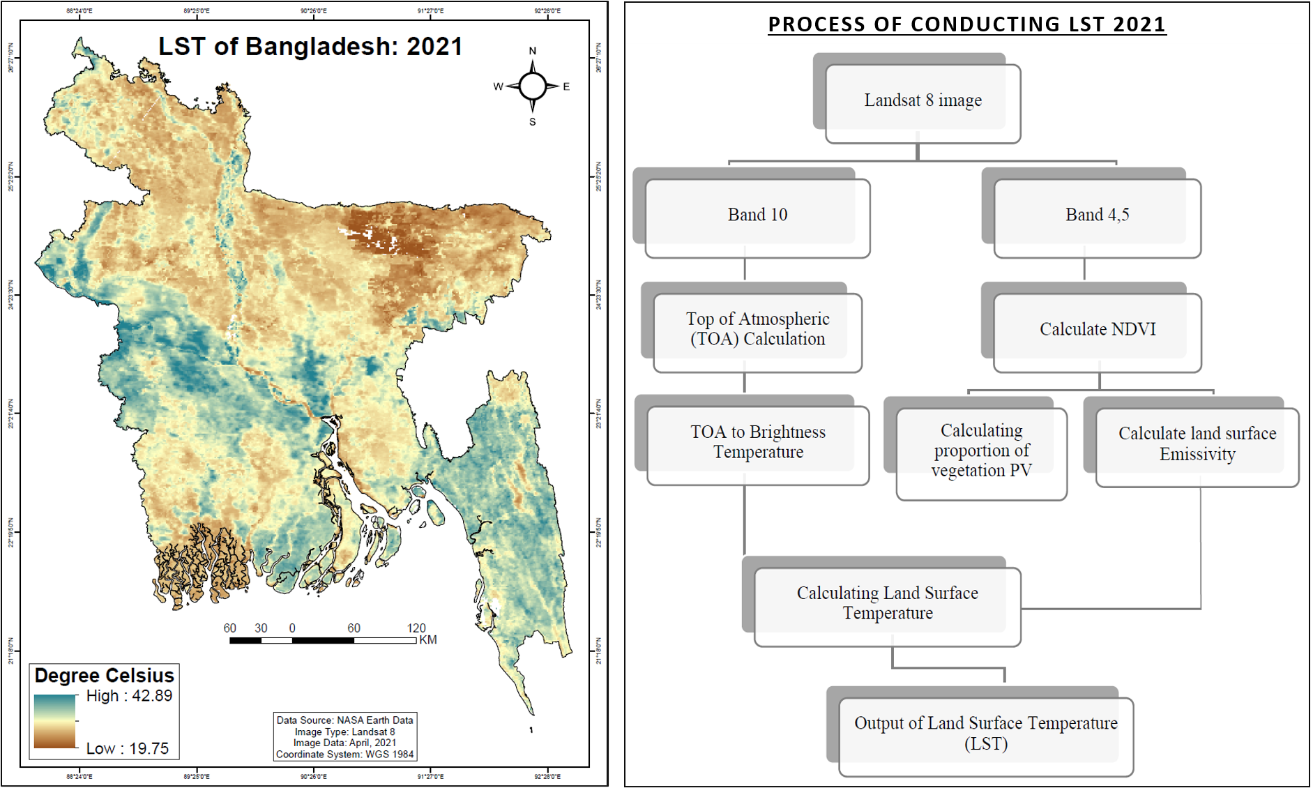
- LST for Bangladesh in April 2021 ranged from 19.75 °C to 42.89 °C, with a national mean of about 31.3 °C.
- Western and southern districts exhibited the highest temperatures, while eastern and coastal regions remained relatively cooler due to vegetation and water influence.
- The LST was derived from Landsat 8 using NDVI-based emissivity correction, integrating atmospheric and brightness temperature calculations.
- The resulting pattern highlights urban heat concentration in major cities such as Dhaka, Khulna, and Rajshahi, confirming the effect of land-cover change on surface warming.
Key Findings (Elevation, Flood & Drought)
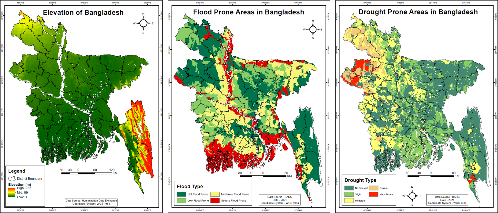
- Elevation: Altitude ranges from <5 m in coastal plains to >900 m in the Chittagong Hill Tracts.
- Flood: High flood susceptibility identified in Satkhira, Khulna, Barguna, Bhola, and Sylhet, where elevation is lowest.
- Drought: Severe drought observed in Rajshahi, Naogaon, Natore, Bogura, and Dinajpur, primarily within the Barind Tract.
- These findings demonstrate strong spatial correlation among elevation, vegetation loss, and environmental hazards.
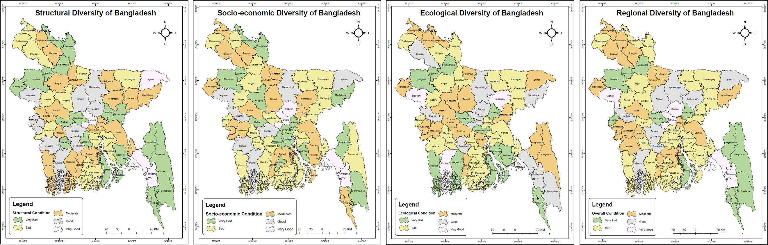
Key Findings (Diversities of Bangladesh)
- Structural Diversity: Higher infrastructure and service accessibility were observed around urban corridors, while rural areas remained less developed.
- Socioeconomic Diversity: Highest scores concentrated in Dhaka, Gazipur, Rajshahi, and Chattogram, reflecting strong employment, education, and income levels.
- Ecological Diversity: Environmentally stable districts include Sylhet, Rangamati, and Bandarban with rich forests and natural reserves.
- Final Regional Diversity: Composite weighted overlay classified 4 districts as very good, 26 as moderate, 23 as bad, and 11 as very bad.
- Spatial Imbalance: It was evident between the western–northern vulnerable zones and the eastern–central developed belt.
- Regional Development: The analysis highlighted priority areas for balanced regional development and targeted policy interventions.